
Xi'an topographic map
Interactive map
Click on the map to display elevation.
About this map
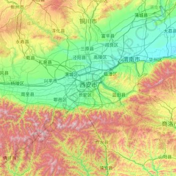
Name: Xi'an topographic map, elevation, terrain.
Location: Xi'an, Shaanxi, China (33.69522 107.65562 34.74595 109.79144)
Average elevation: 974 m
Minimum elevation: 332 m
Maximum elevation: 2,990 m
Xi’an erstreckt sich von 33° 39′ bis 34° 45′ Nord und von 107° 40′ bis 109° 49′ Ost. Es liegt auf 412 m Höhe.
Other topographic maps
Click on a map to view its topography, its elevation and its terrain.