
La Croix topographic map
Interactive map
Click on the map to display elevation.
About this map
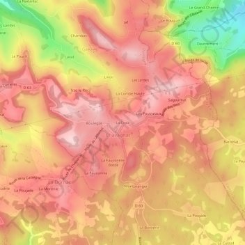
Name: La Croix topographic map, elevation, terrain.
Average elevation: 275 m
Minimum elevation: 113 m
Maximum elevation: 354 m
Other topographic maps
Click on a map to view its topography, its elevation and its terrain.
Grèzes
France > Nouvelle-Aquitaine > Dordogne > Les Coteaux Périgourdins
Grèzes, Les Coteaux Périgourdins, Sarlat-la-Canéda, Dordogne, Nouvelle-Aquitaine, France métropolitaine, 24120, France
Average elevation: 242 m
Chavagnac
France > Nouvelle-Aquitaine > Dordogne > Les Coteaux Périgourdins
Chavagnac, Les Coteaux Périgourdins, Sarlat-la-Canéda, Dordogne, Nouvelle-Aquitaine, France métropolitaine, 24120, France
Average elevation: 251 m
Tour dite de Chavagnac
France > Nouvelle-Aquitaine > Dordogne > Les Coteaux Périgourdins > La Croix
Tour dite de Chavagnac, Place de la Tour, La Croix, Chavagnac, Les Coteaux Périgourdins, Sarlat-la-Canéda, Dordogne, Nouvelle-Aquitaine, France métropolitaine, 24120, France
Average elevation: 296 m