
Thank you for supporting this site ❤️
Make a donation
Make a donation
Bachhausen topographic map
Click on the map to display elevation.
Thank you for supporting this site ❤️
Make a donation
Make a donation
Bachhausen
Allmannshausen | Assenhausen | Aufhausen | Aufkirchen | Bachhausen | Berg | Biberkor | Farchach | Harkirchen | Höhenrain | Kempfenhausen | Leoni | Martinsholzen | Mörlbach | Sibichhausen
Thank you for supporting this site ❤️
Make a donation
Make a donation
About this map
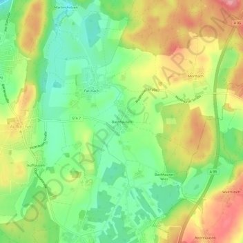
Name: Bachhausen topographic map, elevation, terrain.
Average elevation: 654 m
Minimum elevation: 605 m
Maximum elevation: 713 m
Thank you for supporting this site ❤️
Make a donation
Make a donation
Other topographic maps
Click on a map to view its topography, its elevation and its terrain.
Berg
Deutschland > Bayern > Landkreis Starnberg > Berg
Es gibt die Gemarkungen Bachhausen, Berg, Höhenrain, Kempfenhausen und Wadlhauser Gräben.
Average elevation: 630 m