
Recinto Santa Lucía topographic map
Interactive map
Click on the map to display elevation.
About this map
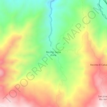
Name: Recinto Santa Lucía topographic map, elevation, terrain.
Location: Recinto Santa Lucía, Echeandía, Bolívar, Ecuador (-1.49658 -79.24624 -1.45658 -79.20624)
Average elevation: 871 m
Minimum elevation: 511 m
Maximum elevation: 1,266 m
Other topographic maps
Click on a map to view its topography, its elevation and its terrain.
Recinto "San Vicente"
Ecuador > Bolívar > Echeandía > Manuel de Echeandia
Recinto "San Vicente", Manuel de Echeandia, Echeandía, Bolívar, 020401, Ecuador
Average elevation: 391 m
Manuel de Echeandia
Manuel de Echeandia, Echeandía, Bolívar, Ecuador
Average elevation: 486 m
Recinto El Tesoro
Ecuador > Bolívar > Echeandía > Manuel de Echeandia > Recinto El Tesoro
Recinto El Tesoro, Manuel de Echeandia, Echeandía, Bolívar, Ecuador
Average elevation: 423 m