Geolocate

Rio Llananzanes topographic map

Interactive map

Click on the map to display elevation.

About this map

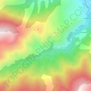
Name: Rio Llananzanes topographic map, elevation, terrain.

Location: Rio Llananzanes, Aller, Asturias, 33681, España (43.05050 -5.61623 43.07060 -5.57201)

Average elevation: 1,096 m

Minimum elevation: 631 m

Maximum elevation: 1,638 m

Other topographic maps

Click on a map to view its topography, its elevation and its terrain.

Pelúgano

España > Asturias > Aller

Pelúgano, Aller, Asturias, 33686, España

Average elevation: 758 m

Casomera

España > Asturias > Aller

Casomera, Aller, Asturias, 33681, España

Average elevation: 946 m

Felechosa

España > Asturias > Aller

Felechosa, Aller, Asturias, 33688, España

Average elevation: 912 m

La Raya

España > Asturias > Aller

La Raya, Aller, Asturias, España

Average elevation: 1,647 m

Moreda

España > Asturias > Aller > Moreda

Moreda, Aller, Asturias, 33670, España

Average elevation: 652 m

Pico los Aberrugues

España > Asturias > Aller

Pico los Aberrugues, Aller, Asturias, 33688, España

Average elevation: 1,248 m

Boo

España > Asturias > Aller > Moreda > Boo

Boo, Moreda, Aller, Asturias, 33675, España

Average elevation: 609 m

Tambarón

España > Asturias > Aller

Tambarón, Aller, Asturias, 33988, España

Average elevation: 758 m

Corigos

España > Asturias > Aller

Corigos, Aller, Asturias, 33676, España

Average elevation: 634 m