
Thank you for supporting this site ❤️
Make a donation
Make a donation
Jabal Qasiyun topographic map
Click on the map to display elevation.
Thank you for supporting this site ❤️
Make a donation
Make a donation
Jabal Qasiyun
The mountain is also host to an endemic species of iris, Iris damascena, which can be found on the steep eastern slopes, at high elevation. The Syrian government has not given the species any protected status but part of the habitat of the species lies within a military area near the Qassioun Republican Guards Military Base and other military facilities, which prevents civilians from accessing the area. The base and steepness of the habitat also prevent construction or development, but it is still classified as "critically endangered".
Thank you for supporting this site ❤️
Make a donation
Make a donation
About this map
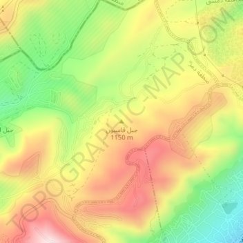
Name: Jabal Qasiyun topographic map, elevation, terrain.
Average elevation: 946 m
Minimum elevation: 735 m
Maximum elevation: 1,142 m
Thank you for supporting this site ❤️
Make a donation
Make a donation