
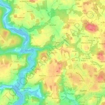
Brangoulo topographic map
Interactive map
Click on the map to display elevation.
About this map
Name: Brangoulo topographic map, elevation, terrain.
Average elevation: 37 m
Minimum elevation: -4 m
Maximum elevation: 70 m
Other topographic maps
Click on a map to view its topography, its elevation and its terrain.
Le Vallon du Pouldu
France > Bretagne > Morbihan > Guidel > Guidel-Plages
Le Vallon du Pouldu, Guidel-Plages, Guidel, Lorient, Morbihan, Bretagne, France métropolitaine, 56520, France
Average elevation: 17 m
Saint-Fiacre
France > Bretagne > Morbihan > Guidel
Saint-Fiacre, Guidel, Lorient, Morbihan, Bretagne, France métropolitaine, 56520, France
Average elevation: 32 m
Guidel-Plages
France > Bretagne > Morbihan > Guidel > Guidel-Plages
Guidel-Plages, Guidel, Lorient, Morbihan, Bretagne, France métropolitaine, 56520, France
Average elevation: 16 m
Saint-Mathieu
France > Bretagne > Morbihan > Guidel > Saint-Mathieu
Saint-Mathieu, Guidel, Lorient, Morbihan, Bretagne, France métropolitaine, 56520, France
Average elevation: 21 m
Le Cruguel
France > Bretagne > Morbihan > Guidel > Guidel-Plages > Le Cruguel
Le Cruguel, Guidel-Plages, Guidel, Lorient, Morbihan, Bretagne, France métropolitaine, 56520, France
Average elevation: 19 m
Moulin de Beg Nénez
France > Bretagne > Morbihan > Guidel
Moulin de Beg Nénez, Guidel, Lorient, Morbihan, Bretagne, France métropolitaine, 56520, France
Average elevation: 33 m