
Thank you for supporting this site ❤️
Make a donation
Make a donation
Simanjiro topographic map
Click on the map to display elevation.
Thank you for supporting this site ❤️
Make a donation
Make a donation
About this map
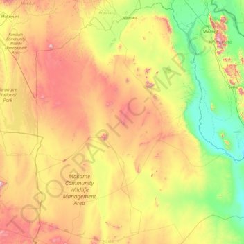
Name: Simanjiro topographic map, elevation, terrain.
Location: Simanjiro, Manyara Region, Northern Zone, Tanzania (-5.19547 36.29166 -3.45162 38.00090)
Average elevation: 1,111 m
Minimum elevation: 607 m
Maximum elevation: 2,068 m
Thank you for supporting this site ❤️
Make a donation
Make a donation
Other topographic maps
Click on a map to view its topography, its elevation and its terrain.