
Thank you for supporting this site ❤️
Make a donation
Make a donation
Beerlegem topographic map
Click on the map to display elevation.
Thank you for supporting this site ❤️
Make a donation
Make a donation
Beerlegem
Beerlegem ligt in Zandlemig Vlaanderen op een hoogte van 25-50 meter. De plaats ligt nabij de Munkbosbeek. De belangrijkste natuurgebieden zijn de Munkbosbeekvallei en de Zavelputten.
Thank you for supporting this site ❤️
Make a donation
Make a donation
About this map
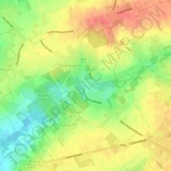
Name: Beerlegem topographic map, elevation, terrain.
Average elevation: 39 m
Minimum elevation: 12 m
Maximum elevation: 63 m
Thank you for supporting this site ❤️
Make a donation
Make a donation
Other topographic maps
Click on a map to view its topography, its elevation and its terrain.