
Forchheim topographic map
Interactive map
Click on the map to display elevation.
About this map
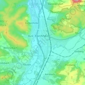
Name: Forchheim topographic map, elevation, terrain.
Location: Forchheim, Landkreis Forchheim, Bayern, 91301, Deutschland (49.67385 10.99958 49.75090 11.12663)
Average elevation: 299 m
Minimum elevation: 250 m
Maximum elevation: 493 m
In dieser Zeit fanden in Forchheim zahlreiche Reichstage und Fürstentage statt. Der erste Aufenthalt eines ostfränkischen Königs ist für 849 belegt. Den Höhepunkt ihrer Bedeutung hatte die Pfalz im Jahre 900, als dort am 4. Februar der erst sechsjährige Ludwig das Kind zum König gewählt und gekrönt wurde. Nach dem Tod des letzten Karolingers wurde in Forchheim am 10. November 911 Konrad I. zum ostfränkischen König gewählt.
Other topographic maps
Click on a map to view its topography, its elevation and its terrain.
St. Walpurgis
Deutschland > Bayern > Landkreis Forchheim > Kirchehrenbach
St. Walpurgis, Kirchehrenbach, Kirchehrenbach (VGem), Landkreis Forchheim, Bayern, 91356, Deutschland
Average elevation: 347 m
Hallerndorf
Deutschland > Bayern > Landkreis Forchheim
Hallerndorf, Landkreis Forchheim, Bayern, 91352, Deutschland
Average elevation: 295 m
Kirchehrenbach
Deutschland > Bayern > Landkreis Forchheim
Kirchehrenbach, Kirchehrenbach (VGem), Landkreis Forchheim, Bayern, 91356, Deutschland
Average elevation: 320 m