
Thank you for supporting this site ❤️
Make a donation
Make a donation
Mata de Lobos topographic map
Click on the map to display elevation.
Thank you for supporting this site ❤️
Make a donation
Make a donation
About this map
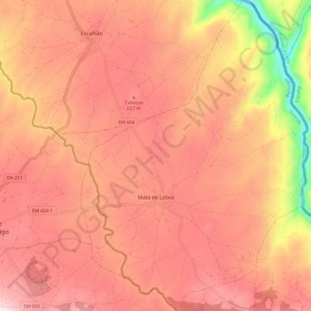
Name: Mata de Lobos topographic map, elevation, terrain.
Location: Mata de Lobos, Figueira de Castelo Rodrigo, Guarda, Portugal (40.87482 -6.92873 40.95900 -6.84735)
Average elevation: 574 m
Minimum elevation: 175 m
Maximum elevation: 770 m
Thank you for supporting this site ❤️
Make a donation
Make a donation
Other topographic maps
Click on a map to view its topography, its elevation and its terrain.