
Thank you for supporting this site ❤️
Make a donation
Make a donation
Eagleview topographic map
Click on the map to display elevation.
Thank you for supporting this site ❤️
Make a donation
Make a donation
About this map
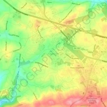
Name: Eagleview topographic map, elevation, terrain.
Average elevation: 151 m
Minimum elevation: 93 m
Maximum elevation: 203 m
Thank you for supporting this site ❤️
Make a donation
Make a donation
Other topographic maps
Click on a map to view its topography, its elevation and its terrain.
flood plane
United States > Pennsylvania > Chester County > Uwchlan Township > Lionville
Average elevation: 149 m