
Thank you for supporting this site ❤️
Make a donation
Make a donation
Canha topographic map
Click on the map to display elevation.
Thank you for supporting this site ❤️
Make a donation
Make a donation
About this map
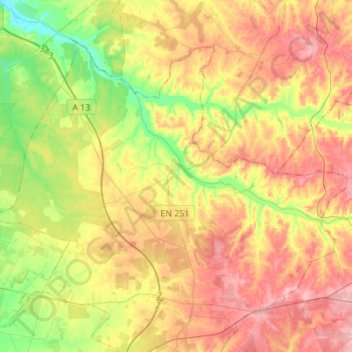
Name: Canha topographic map, elevation, terrain.
Location: Canha, Montijo, Setúbal, Portugal (38.67743 -8.76654 38.84542 -8.49097)
Average elevation: 71 m
Minimum elevation: 5 m
Maximum elevation: 137 m
Thank you for supporting this site ❤️
Make a donation
Make a donation
Other topographic maps
Click on a map to view its topography, its elevation and its terrain.