
Thank you for supporting this site ❤️
Make a donation
Make a donation
Sangone topographic map
Click on the map to display elevation.
Thank you for supporting this site ❤️
Make a donation
Make a donation
About this map
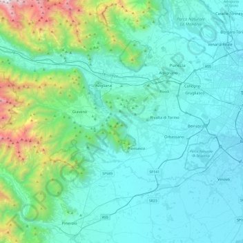
Name: Sangone topographic map, elevation, terrain.
Location: Sangone, Turin, Piedmont, Italy (45.00555 7.19785 45.05034 7.67364)
Average elevation: 574 m
Minimum elevation: 222 m
Maximum elevation: 2,694 m
Thank you for supporting this site ❤️
Make a donation
Make a donation
Other topographic maps
Click on a map to view its topography, its elevation and its terrain.
Thank you for supporting this site ❤️
Make a donation
Make a donation
Thank you for supporting this site ❤️
Make a donation
Make a donation
Thank you for supporting this site ❤️
Make a donation
Make a donation
Thank you for supporting this site ❤️
Make a donation
Make a donation
Thank you for supporting this site ❤️
Make a donation
Make a donation