
Salas pagasts topographic map
Interactive map
Click on the map to display elevation.
About this map
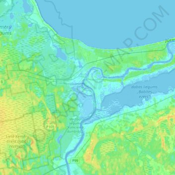
Name: Salas pagasts topographic map, elevation, terrain.
Location: Salas pagasts, Mārupes novads, Lijfland, LV-2105, Letland (56.86969 23.49423 56.97059 23.84722)
Average elevation: 5 m
Minimum elevation: -5 m
Maximum elevation: 22 m
Other topographic maps
Click on a map to view its topography, its elevation and its terrain.
Mārupe
Letland > Lijfland > Mārupes novads > Mārupes pagasts
Mārupe, Mārupes pagasts, Mārupe, Mārupes novads, Lijfland, LV-2167, Letland
Average elevation: 12 m
Spuņciems
Letland > Lijfland > Mārupes novads > Salas pagasts
Spuņciems, Salas pagasts, Mārupes novads, Lijfland, LV-2105, Letland
Average elevation: 2 m