
Thank you for supporting this site ❤️
Make a donation
Make a donation
Moimento topographic map
Click on the map to display elevation.
Thank you for supporting this site ❤️
Make a donation
Make a donation
About this map
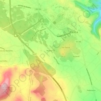
Name: Moimento topographic map, elevation, terrain.
Location: Moimento, Fátima, Ourém, Santarém, 2495-650, Portugal (39.59815 -8.69787 39.63815 -8.65787)
Average elevation: 362 m
Minimum elevation: 240 m
Maximum elevation: 492 m
Thank you for supporting this site ❤️
Make a donation
Make a donation
Other topographic maps
Click on a map to view its topography, its elevation and its terrain.
Thank you for supporting this site ❤️
Make a donation
Make a donation
Thank you for supporting this site ❤️
Make a donation
Make a donation