
Le Grand Montpion topographic map
Interactive map
Click on the map to display elevation.
About this map
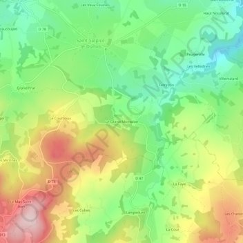
Name: Le Grand Montpion topographic map, elevation, terrain.
Average elevation: 378 m
Minimum elevation: 259 m
Maximum elevation: 537 m
Other topographic maps
Click on a map to view its topography, its elevation and its terrain.
Le Courtioux
France > Nouvelle-Aquitaine > Creuse > Saint-Sulpice-le-Dunois > Le Courtioux
Le Courtioux, Saint-Sulpice-le-Dunois, Guéret, Creuse, Nouvelle-Aquitaine, France métropolitaine, 23800, France
Average elevation: 385 m