
Zemmouri El Bahri topographic map
Interactive map
Click on the map to display elevation.
About this map
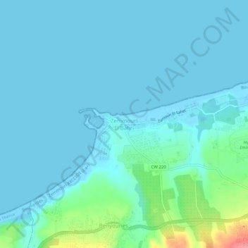
Name: Zemmouri El Bahri topographic map, elevation, terrain.
Average elevation: 12 m
Minimum elevation: -2 m
Maximum elevation: 90 m
Other topographic maps
Click on a map to view its topography, its elevation and its terrain.
Zaatra
Algérie > Boumerdès > Daïra Bordj Menaiel > Zemmouri
Zaatra, Zemmouri, Daïra Bordj Menaiel, Boumerdès, 35200, Algérie
Average elevation: 84 m