
Creston topographic map
Interactive map
Click on the map to display elevation.
About this map
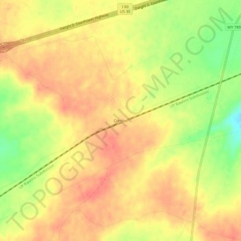
Name: Creston topographic map, elevation, terrain.
Location: Creston, Sweetwater County, Wyoming, United States (41.68385 -107.77674 41.72385 -107.73674)
Average elevation: 2,162 m
Minimum elevation: 2,125 m
Maximum elevation: 2,181 m
Other topographic maps
Click on a map to view its topography, its elevation and its terrain.
North Rock Springs
United States > Wyoming > Sweetwater County
North Rock Springs, Sweetwater County, Wyoming, United States
Average elevation: 2,083 m
Arrowhead Springs
United States > Wyoming > Sweetwater County > Arrowhead Springs
Arrowhead Springs, Sweetwater County, Wyoming, United States
Average elevation: 2,056 m
Rock Springs
United States > Wyoming > Sweetwater County
Rock Springs, Sweetwater County, Wyoming, 82901, United States
Average elevation: 2,024 m
Table Rock
United States > Wyoming > Sweetwater County
Table Rock, Sweetwater County, Wyoming, United States
Average elevation: 2,110 m
Rock Springs
United States > Wyoming > Sweetwater County > Rock Springs
Rock Springs, Sweetwater County, Wyoming, 82901, United States
Average elevation: 2,057 m
Point of Rocks
United States > Wyoming > Sweetwater County
Point of Rocks, Sweetwater County, Wyoming, United States
Average elevation: 2,060 m
White Mountain
United States > Wyoming > Sweetwater County
White Mountain, Sweetwater County, Wyoming, United States
Average elevation: 2,170 m
Green River
United States > Wyoming > Sweetwater County
Green River, Sweetwater County, Wyoming, 82935, United States
Average elevation: 1,985 m