
Thank you for supporting this site ❤️
Make a donation
Make a donation
Huasimpamba topographic map
Click on the map to display elevation.
Thank you for supporting this site ❤️
Make a donation
Make a donation
About this map
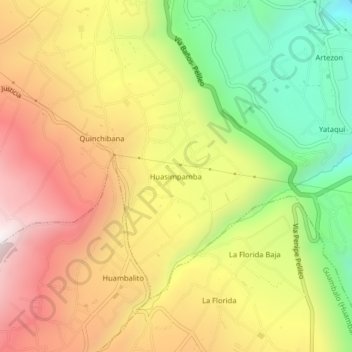
Name: Huasimpamba topographic map, elevation, terrain.
Location: Huasimpamba, Pelileo, Tungurahua, 180701, Ecuador (-1.38072 -78.54769 -1.34072 -78.50769)
Average elevation: 2,583 m
Minimum elevation: 2,008 m
Maximum elevation: 3,123 m
Thank you for supporting this site ❤️
Make a donation
Make a donation