
Thank you for supporting this site ❤️
Make a donation
Make a donation
Kapashera Tehsil topographic map
Click on the map to display elevation.
Thank you for supporting this site ❤️
Make a donation
Make a donation
About this map
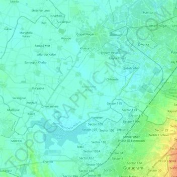
Name: Kapashera Tehsil topographic map, elevation, terrain.
Location: Kapashera Tehsil, South West Delhi District, Delhi, India (28.50083 76.88052 28.60342 77.10257)
Average elevation: 216 m
Minimum elevation: 209 m
Maximum elevation: 250 m
Thank you for supporting this site ❤️
Make a donation
Make a donation
Other topographic maps
Click on a map to view its topography, its elevation and its terrain.
Thank you for supporting this site ❤️
Make a donation
Make a donation
Thank you for supporting this site ❤️
Make a donation
Make a donation
Thank you for supporting this site ❤️
Make a donation
Make a donation
The Garden of Five Senses
India > Delhi > Saket Tehsil > Saidulajaib Extension
Average elevation: 242 m
Thank you for supporting this site ❤️
Make a donation
Make a donation