
Thank you for supporting this site ❤️
Make a donation
Make a donation
Coruche topographic map
Click on the map to display elevation.
Thank you for supporting this site ❤️
Make a donation
Make a donation
About this map
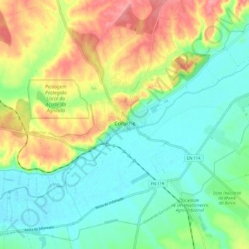
Name: Coruche topographic map, elevation, terrain.
Location: Coruche, Santarém, 2100-042, Portugal (38.91822 -8.56835 38.99822 -8.48835)
Average elevation: 42 m
Minimum elevation: 10 m
Maximum elevation: 97 m
Thank you for supporting this site ❤️
Make a donation
Make a donation
Other topographic maps
Click on a map to view its topography, its elevation and its terrain.