
Thank you for supporting this site ❤️
Make a donation
Make a donation
Caresanablot topographic map
Click on the map to display elevation.
Thank you for supporting this site ❤️
Make a donation
Make a donation
About this map
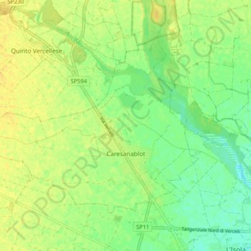
Name: Caresanablot topographic map, elevation, terrain.
Location: Caresanablot, Vercelli, Piedmont, Italy (45.34484 8.33491 45.38237 8.41105)
Average elevation: 135 m
Minimum elevation: 123 m
Maximum elevation: 144 m
Thank you for supporting this site ❤️
Make a donation
Make a donation
Other topographic maps
Click on a map to view its topography, its elevation and its terrain.
Thank you for supporting this site ❤️
Make a donation
Make a donation
Thank you for supporting this site ❤️
Make a donation
Make a donation