
Allos topographic map
Interactive map
Click on the map to display elevation.
Allos
Allos is located some 12 km south of Barcelonnette and some 100 km north-west of Nice at an altitude of 1425 m. The Allos valley is traversed by the Verdon which has its source in the Foux d'Allos in the Sestriere valley at 2500 m altitude.
About this map
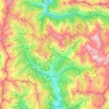
Name: Allos topographic map, elevation, terrain.
Average elevation: 2,097 m
Minimum elevation: 1,289 m
Maximum elevation: 3,024 m
Other topographic maps
Click on a map to view its topography, its elevation and its terrain.
Molanès
France > Provence-Alpes-Côte d'Azur > Alpes-de-Haute-Provence > Uvernet-Fours
Average elevation: 1,566 m
Le Caravon
France > Provence-Alpes-Côte d'Azur > Alpes-de-Haute-Provence > Oppedette
Average elevation: 553 m
Chavailles
France > Provence-Alpes-Côte d'Azur > Alpes-de-Haute-Provence > Prads-Haute-Bléone
Average elevation: 1,491 m
La Croix
France > Provence-Alpes-Côte d'Azur > Alpes-de-Haute-Provence > Jausiers
Average elevation: 2,128 m
Mont d'Or
France > Provence-Alpes-Côte d'Azur > Alpes-de-Haute-Provence > Manosque
Average elevation: 394 m
Saint-Michel
France > Provence-Alpes-Côte d'Azur > Alpes-de-Haute-Provence > Moustiers-Sainte-Marie
Average elevation: 731 m
La Foux d'Allos
France > Provence-Alpes-Côte d'Azur > Alpes-de-Haute-Provence > Allos
Average elevation: 2,094 m
Brame-Faim
France > Provence-Alpes-Côte d'Azur > Alpes-de-Haute-Provence > Mirabeau
Average elevation: 624 m
Barcelonnette
France > Provence-Alpes-Côte d'Azur > Alpes-de-Haute-Provence > Barcelonnette > Barcelonnette
Barcelonnette is situated in the wide and fertile Ubaye Valley, of which it is the largest town. It lies at an elevation of 1132 m (3717 ft) on the right bank of the Ubaye River, and is surrounded by mountains which reach peaks of over 3000 m; the tallest of these is the Needle of Chambeyron at 3412 m.…
Average elevation: 1,494 m
Colmars
France > Provence-Alpes-Côte d'Azur > Alpes-de-Haute-Provence > Colmars > Colmars
Average elevation: 1,565 m
Aurafrède
France > Provence-Alpes-Côte d'Azur > Alpes-de-Haute-Provence > Gréoux-les-Bains
Average elevation: 389 m