
Make a donation
Ilford topographic map
Click on the map to display elevation.
Make a donation
About this map
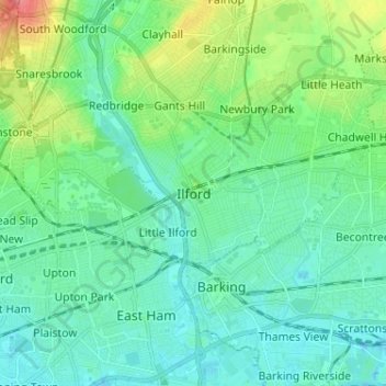
Name: Ilford topographic map, elevation, terrain.
Location: Ilford, Greater London, England, IG1 1DA, United Kingdom (51.51910 0.03368 51.59910 0.11368)
Average elevation: 16 m
Minimum elevation: -2 m
Maximum elevation: 68 m
Make a donation
Other topographic maps
Click on a map to view its topography, its elevation and its terrain.
Make a donation
London Borough of Richmond upon Thames
United Kingdom > England > Greater London
Average elevation: 18 m
Norwood Grove
United Kingdom > England > Greater London
After Anderson died, ownership passed to the Nettlefold family and subsequently to Frederick Nettlefold the brother of Joseph Nettlefold and a member of the family that founded the Nettlefolds Ltd. engineering firm which later became GKN. Nettlefold is commemorated, as a result of his charitable works, by a…
Average elevation: 58 m
Make a donation
Make a donation
Make a donation
Make a donation
Make a donation
Make a donation
Make a donation
Make a donation
Make a donation