
Thank you for supporting this site ❤️
Make a donation
Make a donation
El Pangui topographic map
Click on the map to display elevation.
Thank you for supporting this site ❤️
Make a donation
Make a donation
About this map
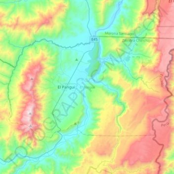
Name: El Pangui topographic map, elevation, terrain.
Location: El Pangui, Zamora Chinchipe, Ecuador (-3.72207 -78.69843 -3.52816 -78.36765)
Average elevation: 1,283 m
Minimum elevation: 731 m
Maximum elevation: 2,336 m
Thank you for supporting this site ❤️
Make a donation
Make a donation
Other topographic maps
Click on a map to view its topography, its elevation and its terrain.