
Eastern Province topographic map
Interactive map
Click on the map to display elevation.
About this map
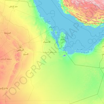
Name: Eastern Province topographic map, elevation, terrain.
Location: Eastern Province, Saudi Arabia (19.00050 44.64599 29.15925 55.66669)
Average elevation: 329 m
Minimum elevation: -14 m
Maximum elevation: 2,962 m
Other topographic maps
Click on a map to view its topography, its elevation and its terrain.
Abha
Abha is located in the southern region of Asir at an elevation of about 2,270 metres (7,450 feet) above sea level. Abha lies on the western edge of Mount Al-Hijaz, near Jabal Sawda, the highest peak in Saudi Arabia. Treating the Asir Mountains as part of the Sarawat, the landscape is otherwise dominated by the…
Average elevation: 1,994 m
At Ta'if
Taif (Arabic: اَلطَّائِفُ, romanized: aṭ-Ṭāʾif, lit. 'The circulated or encircled', Hejazi Arabic pronunciation: [atˤˈ tˤaːjɪf]) is a city and governorate in the Mecca Province of Saudi Arabia. Located at an elevation of 1,879 m (6,165 ft) in the slopes of the Hijaz Mountains, which…
Average elevation: 1,742 m