Geolocate

Kuyavian-Pomeranian Voivodeship topographic map

Interactive map

Click on the map to display elevation.

About this map

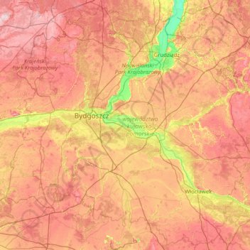
Name: Kuyavian-Pomeranian Voivodeship topographic map, elevation, terrain.

Location: Kuyavian-Pomeranian Voivodeship, Poland (52.33064 17.24727 53.78108 19.76160)

Average elevation: 98 m

Minimum elevation: 8 m

Maximum elevation: 211 m

Other topographic maps

Click on a map to view its topography, its elevation and its terrain.

Greater Poland Voivodeship

Poland

The highest elevation is Greater Kobyla Mountain (284 m) in the Ostrzeszowski Hills, the lowest area is located in the valley of the Warta River at the mouth of its tributary the Noteć (21 m) in the north-western part of the region. Agriculturally fertile soils account for around 60% of the province's area,…

Average elevation: 110 m

Subcarpathian Voivodeship

Poland

Average elevation: 333 m

Mińsk County

Poland > Masovian Voivodeship

Average elevation: 143 m

Lesser Poland Voivodeship

Poland

Average elevation: 450 m

Łódź

Poland > Łódzkie Voivodship

Łódź covers an area of approximately 293 square kilometres (113 sq mi) and is located in the centre of Poland. The city lies in the lowlands of the Central European Plain, not exceeding 300 metres in elevation. Topographically, the Łódź region is generally characterised by a flat landscape, with only…

Average elevation: 203 m

Kołowo

Poland > West Pomeranian Voivodeship > Kołowo

Average elevation: 103 m

Brwinów

Poland > Masovian Voivodeship > Brwinów

Average elevation: 97 m

Iłża

Poland > Masovian Voivodeship > Iłża

Average elevation: 204 m

Pruszków County

Poland > Masovian Voivodeship

Average elevation: 116 m

Pruszków

Poland > Masovian Voivodeship > Pruszków

Average elevation: 99 m

Stock

Poland > Podlaskie Voivodeship > Stock

Average elevation: 151 m

Łódź

Poland > Łódź Voivodeship

Average elevation: 206 m

Silesian Voivodeship

Poland

Average elevation: 337 m

Śródmieście

Poland > Pomeranian Voivodeship > Gdansk

Average elevation: 10 m

Sejny

Poland > Podlaskie Voivodeship > Sejny

Average elevation: 136 m

Podlaskie Voivodeship

Poland

It has a varied landscape, shaped in the north by Baltic glaciation, the rest by Middle Poland glaciation. The highest peaks are in the north (Rowelska Top - 298 m), where the landscape is dominated by a hilly lake district. Lakeland: Zachodniosuwalskie, Wschodniosuwalskie, Ełckie) and Sandrowy lake district…

Average elevation: 138 m

Praga-Południe

Poland > Masovian Voivodeship > Warsaw

Average elevation: 86 m

Lipno

Poland > Kuyavian-Pomeranian Voivodeship > Lipno

Average elevation: 103 m

Masovian Voivodeship

Poland

Average elevation: 146 m

Chałupki

Poland > Silesian Voivodeship > Chałupki

Average elevation: 202 m

Kłodzko

Poland > Lower Silesian Voivodeship > Kłodzko

Average elevation: 332 m

Warsaw

Poland > Masovian Voivodeship > Warsaw

Warsaw lies in east-central Poland about 300 km (190 mi) from the Carpathian Mountains and about 260 km (160 mi) from the Baltic Sea, 523 km (325 mi) east of Berlin, Germany. The city straddles the Vistula River. It is located in the heartland of the Masovian Plain, and its average elevation is 100 metres (330…

Average elevation: 96 m

Nowy Targ

Poland > Lesser Poland Voivodeship > Nowy Targ

Average elevation: 679 m

Radom

Poland > Masovian Voivodeship > Radom

Average elevation: 168 m