
Thank you for supporting this site ❤️
Make a donation
Make a donation
Zingem topographic map
Click on the map to display elevation.
Thank you for supporting this site ❤️
Make a donation
Make a donation
Zingem
Zingem ligt aan de Schelde op een hoogte van ongeveer 17 meter.
Thank you for supporting this site ❤️
Make a donation
Make a donation
About this map
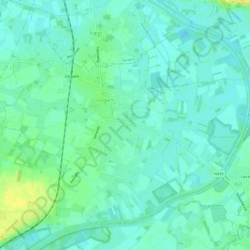
Name: Zingem topographic map, elevation, terrain.
Location: Zingem, Kruisem, Oudenaarde, Oost-Vlaanderen, België (50.88627 3.63026 50.91450 3.68666)
Average elevation: 11 m
Minimum elevation: 3 m
Maximum elevation: 30 m
Thank you for supporting this site ❤️
Make a donation
Make a donation
Other topographic maps
Click on a map to view its topography, its elevation and its terrain.