
Thank you for supporting this site ❤️
Make a donation
Make a donation
Hinzenbach topographic map
Click on the map to display elevation.
Thank you for supporting this site ❤️
Make a donation
Make a donation
About this map
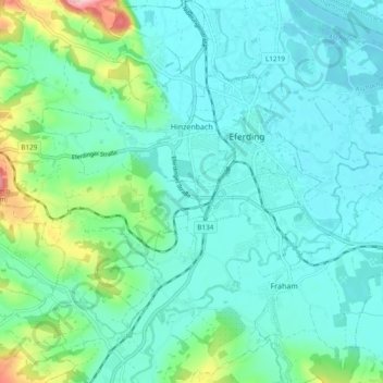
Name: Hinzenbach topographic map, elevation, terrain.
Location: Hinzenbach, Bezirk Eferding, Upper Austria, 4070, Austria (48.26766 13.94375 48.33059 14.01583)
Average elevation: 291 m
Minimum elevation: 257 m
Maximum elevation: 436 m
Thank you for supporting this site ❤️
Make a donation
Make a donation
Other topographic maps
Click on a map to view its topography, its elevation and its terrain.
Schlögen
Austria > Upper Austria > Bezirk Eferding > Haibach ob der Donau > Schlögen
Average elevation: 458 m