
Thank you for supporting this site ❤️
Make a donation
Make a donation
Speyer topographic map
Click on the map to display elevation.
Thank you for supporting this site ❤️
Make a donation
Make a donation
About this map
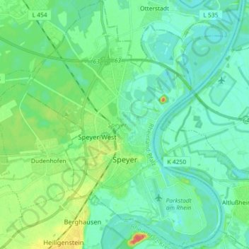
Name: Speyer topographic map, elevation, terrain.
Location: Speyer, Rhineland-Palatinate, 67346, Germany (49.28306 8.37685 49.37601 8.49183)
Average elevation: 100 m
Minimum elevation: 89 m
Maximum elevation: 134 m
Thank you for supporting this site ❤️
Make a donation
Make a donation
Other topographic maps
Click on a map to view its topography, its elevation and its terrain.
Pellenberg
Germany > Rhineland-Palatinate > Landkreis Trier-Saarburg > Merzkirchen
Average elevation: 347 m