Geolocate

Yunfu City topographic map

Interactive map

Click on the map to display elevation.

About this map

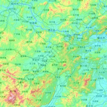
Name: Yunfu City topographic map, elevation, terrain.

Location: Yunfu City, Guangdong Province, China (22.36725 111.05273 23.33082 112.51671)

Average elevation: 227 m

Minimum elevation: -2 m

Maximum elevation: 1,677 m

Other topographic maps

Click on a map to view its topography, its elevation and its terrain.

Guangzhou City

China > Guangdong Province

The elevation of the prefecture generally increases from southwest to northeast, with mountains forming the backbone of the city and the ocean comprising the front. Tiantang Peak (simplified Chinese: 天堂顶; traditional Chinese: 天堂頂, "Heavenly Peak") is the highest point of elevation at 1,210 m (3,970…

Average elevation: 98 m

Dongguan

China > Guangdong Province > Dongguan

Average elevation: 20 m

Shaxi

China > Guangdong Province > Zhongshan > Shaxi > Shenmingtingcun

Average elevation: 8 m