
Make a donation
Westenholz topographic map
Click on the map to display elevation.
Make a donation
About this map
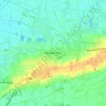
Name: Westenholz topographic map, elevation, terrain.
Average elevation: 86 m
Minimum elevation: 76 m
Maximum elevation: 105 m
Make a donation
Other topographic maps
Click on a map to view its topography, its elevation and its terrain.
Westenholz
Deutschland > Nordrhein-Westfalen > Kreis Paderborn > Delbrück > Westenholz
Average elevation: 82 m
Anreppen
Deutschland > Nordrhein-Westfalen > Kreis Paderborn > Delbrück
Anreppen liegt im südöstlichen Winkel der Westfälischen Bucht direkt nördlich der Lippe bei 51° 45′ n. Br., 8° 34′ ö. L. auf einer Höhe von 90 m ü. NN. Laut der heute meist benutzten Einteilung im Handbuch der naturräumlichen Gliederung Deutschlands liegt der Ort in der Untereinheit 540.20 Obere…
Average elevation: 92 m
Ostenland
Deutschland > Nordrhein-Westfalen > Kreis Paderborn > Delbrück > Wittendorf
Average elevation: 101 m
Boke
Deutschland > Nordrhein-Westfalen > Kreis Paderborn > Delbrück
Boke gehört wie Ostwestfalen-Lippe insgesamt zum ozeanischen Klimabereich Nordwestdeutschlands, dem es geringe Temperaturgegensätze und milde Winter verdankt. Allerdings sind schon kontinentale Einflüsse wirksam. So liegt die Temperatur im Sommer höher und die Nächte sind kühler als in größerer Nähe…
Average elevation: 90 m
Make a donation