
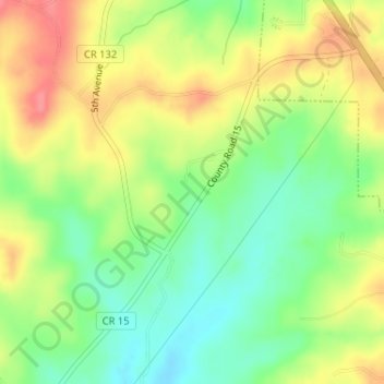
Wedowee Club Lake Dam topographic map
Interactive map
Click on the map to display elevation.
About this map
Name: Wedowee Club Lake Dam topographic map, elevation, terrain.
Average elevation: 280 m
Minimum elevation: 245 m
Maximum elevation: 319 m
Other topographic maps
Click on a map to view its topography, its elevation and its terrain.
Wedowee
United States > Alabama > Randolph County
Wedowee, Randolph County, Alabama, United States
Average elevation: 278 m
Roanoke
United States > Alabama > Randolph County
Roanoke, Randolph County, Alabama, 36274, United States
Average elevation: 252 m
High Pine
United States > Alabama > Randolph County
High Pine, Randolph County, Alabama, United States
Average elevation: 235 m
Flat Rock
United States > Alabama > Randolph County
Flat Rock, Randolph County, Alabama, United States
Average elevation: 253 m
Melody Lane
United States > Alabama > Randolph County > Roanoke
Melody Lane, Roanoke, Randolph County, Alabama, 36274, United States
Average elevation: 262 m
Woodland
United States > Alabama > Randolph County
Woodland, Randolph County, Alabama, 36280, United States
Average elevation: 313 m
Newell
United States > Alabama > Randolph County > Newell
Newell, Randolph County, Alabama, 36270, United States
Average elevation: 286 m
Wadley
United States > Alabama > Randolph County
Wadley, Randolph County, Alabama, United States
Average elevation: 209 m
Roanoke
United States > Alabama > Randolph County > Roanoke
Roanoke, Randolph County, Alabama, 36274, United States
Average elevation: 251 m