
Manmangalam topographic map
Interactive map
Click on the map to display elevation.
About this map
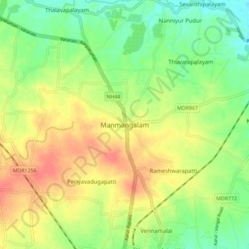
Name: Manmangalam topographic map, elevation, terrain.
Location: Manmangalam, Karur, Karur District, Tamil Nadu, 639006, India (10.98612 78.02520 11.06612 78.10520)
Average elevation: 141 m
Minimum elevation: 114 m
Maximum elevation: 169 m
Other topographic maps
Click on a map to view its topography, its elevation and its terrain.
Pugalur
India > Tamil Nadu > Karur
Pugalur, Karur, Karur District, Tamil Nadu, 639117, India
Average elevation: 134 m