
Wutachschlucht topographic map
Interactive map
Click on the map to display elevation.
About this map
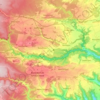
Name: Wutachschlucht topographic map, elevation, terrain.
Average elevation: 792 m
Minimum elevation: 534 m
Maximum elevation: 997 m
Other topographic maps
Click on a map to view its topography, its elevation and its terrain.
Tiefental
Deutschland > Baden-Württemberg > Landkreis Waldshut > Bonndorf im Schwarzwald
Tiefental, Bonndorf im Schwarzwald, Verwaltungsgemeinschaft Bonndorf im Schwarzwald, Landkreis Waldshut, Baden-Württemberg, 79848, Deutschland
Average elevation: 810 m
Dillendorf
Deutschland > Baden-Württemberg > Landkreis Waldshut > Bonndorf im Schwarzwald
Dillendorf, Bonndorf im Schwarzwald, Verwaltungsgemeinschaft Bonndorf im Schwarzwald, Landkreis Waldshut, Baden-Württemberg, 79879, Deutschland
Average elevation: 741 m
Brunnadern
Deutschland > Baden-Württemberg > Landkreis Waldshut > Bonndorf im Schwarzwald > Brunnadern
Brunnadern, Bonndorf im Schwarzwald, Verwaltungsgemeinschaft Bonndorf im Schwarzwald, Landkreis Waldshut, Baden-Württemberg, Deutschland
Average elevation: 754 m