
Thank you for supporting this site ❤️
Make a donation
Make a donation
Cwmafan topographic map
Click on the map to display elevation.
Thank you for supporting this site ❤️
Make a donation
Make a donation
About this map
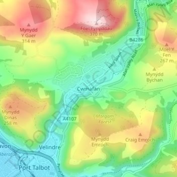
Name: Cwmafan topographic map, elevation, terrain.
Location: Cwmafan, Neath Port Talbot, Wales, SA12 9AP, United Kingdom (51.59308 -3.78266 51.63308 -3.74266)
Average elevation: 146 m
Minimum elevation: 3 m
Maximum elevation: 370 m
Thank you for supporting this site ❤️
Make a donation
Make a donation
Other topographic maps
Click on a map to view its topography, its elevation and its terrain.
Thank you for supporting this site ❤️
Make a donation
Make a donation
Thank you for supporting this site ❤️
Make a donation
Make a donation