
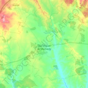
São Miguel de Machede topographic map
Interactive map
Click on the map to display elevation.
About this map
Name: São Miguel de Machede topographic map, elevation, terrain.
Location: São Miguel de Machede, Évora, Portugal (38.59890 -7.82502 38.70115 -7.66687)
Average elevation: 253 m
Minimum elevation: 200 m
Maximum elevation: 356 m
Other topographic maps
Click on a map to view its topography, its elevation and its terrain.
Évora
O município de Évora localiza-se em meio à grande planície alentejana, caracterizada por uma ondulação muito suave e altitude média de 240 metros. Com uma área de 1 309 km², o município ocupa 5% da superfície da região do Alentejo. A área urbana de Évora abrange 1643 ha.
Average elevation: 254 m