
Thank you for supporting this site ❤️
Make a donation
Make a donation
Passadouro topographic map
Click on the map to display elevation.
Thank you for supporting this site ❤️
Make a donation
Make a donation
About this map
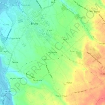
Name: Passadouro topographic map, elevation, terrain.
Average elevation: 27 m
Minimum elevation: -5 m
Maximum elevation: 64 m
Thank you for supporting this site ❤️
Make a donation
Make a donation
Other topographic maps
Click on a map to view its topography, its elevation and its terrain.
Praia da Costa Nova
Portugal > Aveiro > Ílhavo > Gafanha da Encarnação > Costa Nova
Average elevation: 1 m