
Hornesselwiese topographic map
Interactive map
Click on the map to display elevation.
About this map
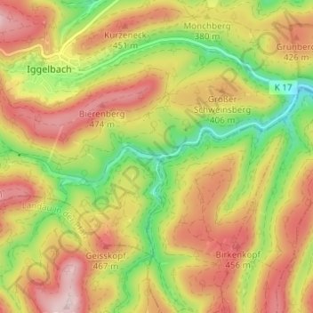
Name: Hornesselwiese topographic map, elevation, terrain.
Average elevation: 372 m
Minimum elevation: 226 m
Maximum elevation: 504 m
Other topographic maps
Click on a map to view its topography, its elevation and its terrain.
Geisskopf
Deutschland > Rheinland-Pfalz > Landkreis Bad Dürkheim > Elmstein
Geisskopf, Elmstein, Lambrecht (Pfalz), Landkreis Bad Dürkheim, Rheinland-Pfalz, 67471, Deutschland
Average elevation: 378 m