
Aziz topographic map
Interactive map
Click on the map to display elevation.
About this map
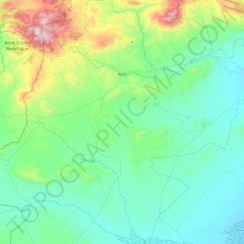
Name: Aziz topographic map, elevation, terrain.
Location: Aziz, Daïra Aziz, Médéa, 26040, Algérie (35.58114 2.34731 35.92920 2.65826)
Average elevation: 884 m
Minimum elevation: 650 m
Maximum elevation: 1,801 m
Aziz étant situé au sud de Médéa et a une altitude de 800 m, son climat est sec l'été, pluvieux et froid l'hiver. Au nord le relief est montagneux et culmine au Djebel Taquensa à 1 720 m.