
Thank you for supporting this site ❤️
Make a donation
Make a donation
Rømskog topographic map
Click on the map to display elevation.
Thank you for supporting this site ❤️
Make a donation
Make a donation
About this map
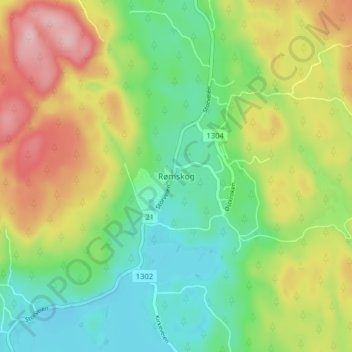
Name: Rømskog topographic map, elevation, terrain.
Location: Rømskog, Aurskog-Høland, Viken, 1950, Norway (59.72926 11.79286 59.76926 11.83286)
Average elevation: 209 m
Minimum elevation: 134 m
Maximum elevation: 325 m
Thank you for supporting this site ❤️
Make a donation
Make a donation
Other topographic maps
Click on a map to view its topography, its elevation and its terrain.
Thank you for supporting this site ❤️
Make a donation
Make a donation
Thank you for supporting this site ❤️
Make a donation
Make a donation
Thank you for supporting this site ❤️
Make a donation
Make a donation