
Lac-Clair topographic map
Interactive map
Click on the map to display elevation.
About this map
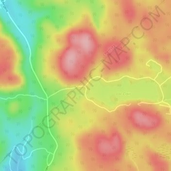
Name: Lac-Clair topographic map, elevation, terrain.
Location: Lac-Clair, Rawdon, Matawinie, Lanaudière, Québec, Canada (46.08309 -73.81618 46.10309 -73.79618)
Average elevation: 314 m
Minimum elevation: 227 m
Maximum elevation: 381 m
Other topographic maps
Click on a map to view its topography, its elevation and its terrain.
Chute Magnan
Chute Magnan, Rue Mason, Rawdon, Matawinie, Lanaudière, Québec, J0K 1S0, Canada
Average elevation: 175 m
Lac aux Sources
Lac aux Sources, Chemin Saint-Alphonse, Rawdon, Matawinie, Lanaudière, Québec, J0K 1S0, Canada
Average elevation: 236 m