
Thank you for supporting this site ❤️
Make a donation
Make a donation
Mangualde topographic map
Click on the map to display elevation.
Thank you for supporting this site ❤️
Make a donation
Make a donation
Mangualde
On 3 July 1986, the Portuguese Assembly ratified the elevation of the town to the category of city.
Thank you for supporting this site ❤️
Make a donation
Make a donation
About this map
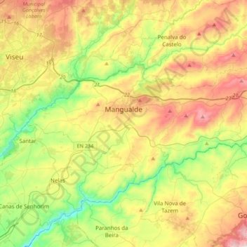
Name: Mangualde topographic map, elevation, terrain.
Location: Mangualde, Viseu, Portugal (40.52592 -7.89691 40.65154 -7.56175)
Average elevation: 443 m
Minimum elevation: 150 m
Maximum elevation: 856 m
Thank you for supporting this site ❤️
Make a donation
Make a donation
Other topographic maps
Click on a map to view its topography, its elevation and its terrain.
Thank you for supporting this site ❤️
Make a donation
Make a donation
Thank you for supporting this site ❤️
Make a donation
Make a donation
Thank you for supporting this site ❤️
Make a donation
Make a donation
Casal de Cima
Portugal > Viseu > Vilar de Besteiros e Mosteiro de Fráguas > Vilar de Besteiros > Casal de Cima
Average elevation: 338 m
Pedreles
Portugal > Viseu > Fornos de Maceira Dão > Fornos de Maceira Dão > Pedreles
Average elevation: 447 m
Thank you for supporting this site ❤️
Make a donation
Make a donation