
Thank you for supporting this site ❤️
Make a donation
Make a donation
Florence topographic map
Click on the map to display elevation.
Thank you for supporting this site ❤️
Make a donation
Make a donation
About this map
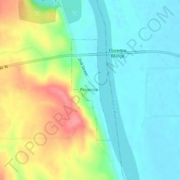
Name: Florence topographic map, elevation, terrain.
Location: Florence, Pike County, Illinois, United States (39.61963 -90.61411 39.63480 -90.60642)
Average elevation: 157 m
Minimum elevation: 128 m
Maximum elevation: 213 m
Thank you for supporting this site ❤️
Make a donation
Make a donation
Other topographic maps
Click on a map to view its topography, its elevation and its terrain.