
Thank you for supporting this site ❤️
Make a donation
Make a donation
Caripe topographic map
Click on the map to display elevation.
Thank you for supporting this site ❤️
Make a donation
Make a donation
About this map
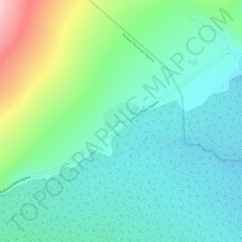
Name: Caripe topographic map, elevation, terrain.
Average elevation: 4,207 m
Minimum elevation: 4,147 m
Maximum elevation: 4,358 m
Thank you for supporting this site ❤️
Make a donation
Make a donation
Other topographic maps
Click on a map to view its topography, its elevation and its terrain.
Ovejuyo
Bolivia > Oruro > Provincia Sajama > Municipio Curahuara de Carangas
Average elevation: 4,245 m
Nevado Sajama
Bolivia > Oruro > Provincia Sajama > Municipio Curahuara de Carangas
Average elevation: 5,801 m