
Thank you for supporting this site ❤️
Make a donation
Make a donation
Faro do Alentejo topographic map
Click on the map to display elevation.
Thank you for supporting this site ❤️
Make a donation
Make a donation
About this map
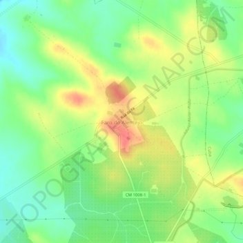
Name: Faro do Alentejo topographic map, elevation, terrain.
Location: Faro do Alentejo, Cuba, Beja, 7940-311, Portugal (38.12852 -7.96151 38.16852 -7.92151)
Average elevation: 177 m
Minimum elevation: 151 m
Maximum elevation: 208 m
Thank you for supporting this site ❤️
Make a donation
Make a donation
Other topographic maps
Click on a map to view its topography, its elevation and its terrain.