
Thank you for supporting this site ❤️
Make a donation
Make a donation
Kurshim district topographic map
Click on the map to display elevation.
Thank you for supporting this site ❤️
Make a donation
Make a donation
About this map
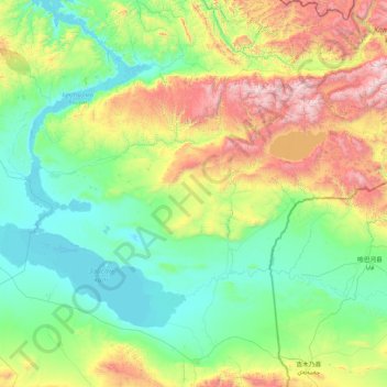
Name: Kurshim district topographic map, elevation, terrain.
Location: Kurshim district, East Kazakhstan Region, 071200, Kazakhstan (47.80693 83.42142 49.11727 85.62701)
Average elevation: 714 m
Minimum elevation: 386 m
Maximum elevation: 2,865 m
Thank you for supporting this site ❤️
Make a donation
Make a donation
Other topographic maps
Click on a map to view its topography, its elevation and its terrain.
Винное
Kazakhstan > East Kazakhstan Region > Glubokoe District > Тарханка ауылдық округі
Average elevation: 379 m
Жоғарғы Үбі
Kazakhstan > East Kazakhstan Region > Shemonaikha District > Жоғарғы Үбі ауылдық округі
Average elevation: 368 m
Border Kazakhstan - Russia
Kazakhstan > East Kazakhstan Region > Katonkaragay District
Average elevation: 2,676 m
Thank you for supporting this site ❤️
Make a donation
Make a donation
Border Kazakhstan - Russia
Kazakhstan > East Kazakhstan Region > Katonkaragay District
Average elevation: 2,714 m
Thank you for supporting this site ❤️
Make a donation
Make a donation