
Thank you for supporting this site ❤️
Make a donation
Make a donation
Cesara topographic map
Click on the map to display elevation.
Thank you for supporting this site ❤️
Make a donation
Make a donation
About this map
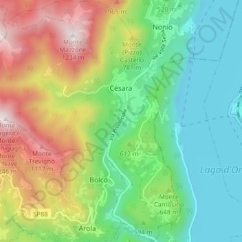
Name: Cesara topographic map, elevation, terrain.
Location: Cesara, Verbano-Cusio-Ossola, Piedmont, Italy (45.80578 8.32097 45.85073 8.38230)
Average elevation: 612 m
Minimum elevation: 277 m
Maximum elevation: 1,219 m
Thank you for supporting this site ❤️
Make a donation
Make a donation
Other topographic maps
Click on a map to view its topography, its elevation and its terrain.
Thank you for supporting this site ❤️
Make a donation
Make a donation
Mottarone
Italy > Piedmont > Verbano-Cusio-Ossola > Stresa
Mottarone is a mountain in the Western Alps of Piedmont, north-western Italy, with an elevation of 1,492 metres (4,895 ft). It is located between the provinces of Verbano-Cusio-Ossola and Novara.
Average elevation: 1,177 m
Thank you for supporting this site ❤️
Make a donation
Make a donation
Thank you for supporting this site ❤️
Make a donation
Make a donation
Thank you for supporting this site ❤️
Make a donation
Make a donation
Giardini Botanici Villa Taranto
Italy > Piedmont > Verbano-Cusio-Ossola > Verbania
Average elevation: 210 m