
Bradford topographic map
Interactive map
Click on the map to display elevation.
About this map
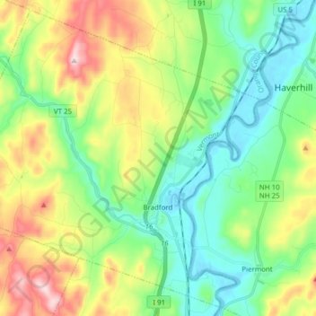
Name: Bradford topographic map, elevation, terrain.
Location: Bradford, Orange County, Vermont, 05033, United States (43.95741 -72.23283 44.06142 -72.07923)
Average elevation: 255 m
Minimum elevation: 114 m
Maximum elevation: 543 m
According to the United States Census Bureau, the town has a total area of 29.9 square miles (77.4 km2), of which 29.8 square miles (77.2 km2) is land and 0.1 square mile (0.2 km2) (0.20%) is water. The Waits River flows through Bradford in a southeasterly direction to its confluence with the Connecticut River, which forms the eastern boundary of the town. The town rises from the river's meadows through low hills and river valleys and finally Wright's Mountain (at an elevation of 1,822 feet) close to the border with Newbury to the north.
Other topographic maps
Click on a map to view its topography, its elevation and its terrain.
Brookfield Center
United States > Vermont > Orange County > Brookfield
Brookfield Center, Brookfield, Orange County, Vermont, 05036, United States
Average elevation: 422 m
West Newbury
United States > Vermont > Orange County > Newbury
West Newbury, Newbury, Orange County, Vermont, 05085, United States
Average elevation: 311 m
Williamstown
United States > Vermont > Orange County
Williamstown, Orange County, Vermont, 05679, United States
Average elevation: 441 m
South Vershire
United States > Vermont > Orange County > Vershire
South Vershire, Vershire, Orange County, Vermont, 05079, United States
Average elevation: 472 m
Fairlee
United States > Vermont > Orange County
Fairlee, Orange County, Vermont, 05045, United States
Average elevation: 268 m
Washington
United States > Vermont > Orange County
Washington, Orange County, Vermont, United States
Average elevation: 510 m
South Strafford
United States > Vermont > Orange County > Strafford
South Strafford, Strafford, Orange County, Vermont, 05070, United States
Average elevation: 367 m
Randolph Center
United States > Vermont > Orange County > Randolph
Randolph Center, Randolph, Orange County, Vermont, 05061, United States
Average elevation: 380 m
Union Village
United States > Vermont > Orange County > Thetford
Union Village, Thetford, Orange County, Vermont, 05075, United States
Average elevation: 217 m
East Corinth
United States > Vermont > Orange County > Corinth
East Corinth, Corinth, Orange County, Vermont, 05040, United States
Average elevation: 292 m
Wells River
United States > Vermont > Orange County > Newbury
Wells River, Newbury, Orange County, Vermont, 05081, United States
Average elevation: 194 m
Strafford
United States > Vermont > Orange County
Strafford, Orange County, Vermont, United States
Average elevation: 421 m
West Fairlee
United States > Vermont > Orange County > West Fairlee
West Fairlee, Orange County, Vermont, 05083, United States
Average elevation: 379 m
Corinth
United States > Vermont > Orange County > Corinth
Corinth, Orange County, Vermont, 05039, United States
Average elevation: 410 m
Thetford Center
United States > Vermont > Orange County > Thetford > Thetford Center
Thetford Center, Thetford, Orange County, Vermont, 05074, United States
Average elevation: 262 m
Tunbridge
United States > Vermont > Orange County
Tunbridge, Orange County, Vermont, 05077, United States
Average elevation: 362 m
Newbury
United States > Vermont > Orange County
Newbury, Orange County, Vermont, United States
Average elevation: 264 m
Orange
United States > Vermont > Orange County > Orange
Orange, Orange County, Vermont, 05649, United States
Average elevation: 510 m
Brookfield
United States > Vermont > Orange County
Brookfield, Orange County, Vermont, 05036, United States
Average elevation: 417 m
Vershire
United States > Vermont > Orange County
Vershire, Orange County, Vermont, 05079, United States
Average elevation: 463 m
Randolph
United States > Vermont > Orange County
Randolph, Orange County, Vermont, United States
Average elevation: 367 m
Chelsea
United States > Vermont > Orange County
Chelsea, Orange County, Vermont, 05038, United States
Average elevation: 464 m